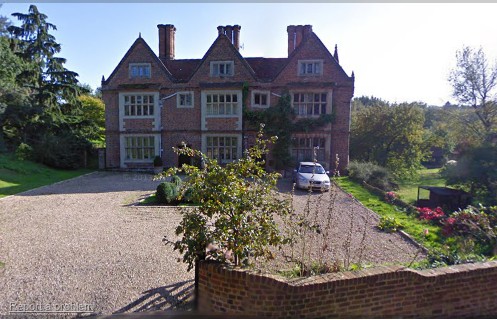
Rear View of Waterend House (1830)
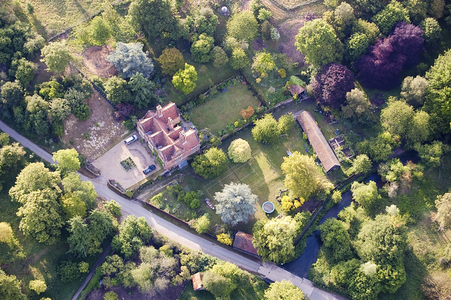
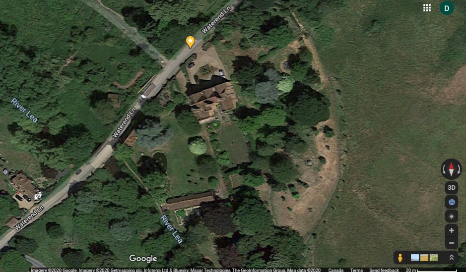
Aerial View of WaterEnd House (c2000)
Directly Overhead View of WaterEnd House (c2020)
Introduction:
The Ayot Estate forms what was the Western part of the Brocket Estate. The estate derives
its name from the word Ayot, which is particular to Hertfordshire and means a high place, an island between two rivers.
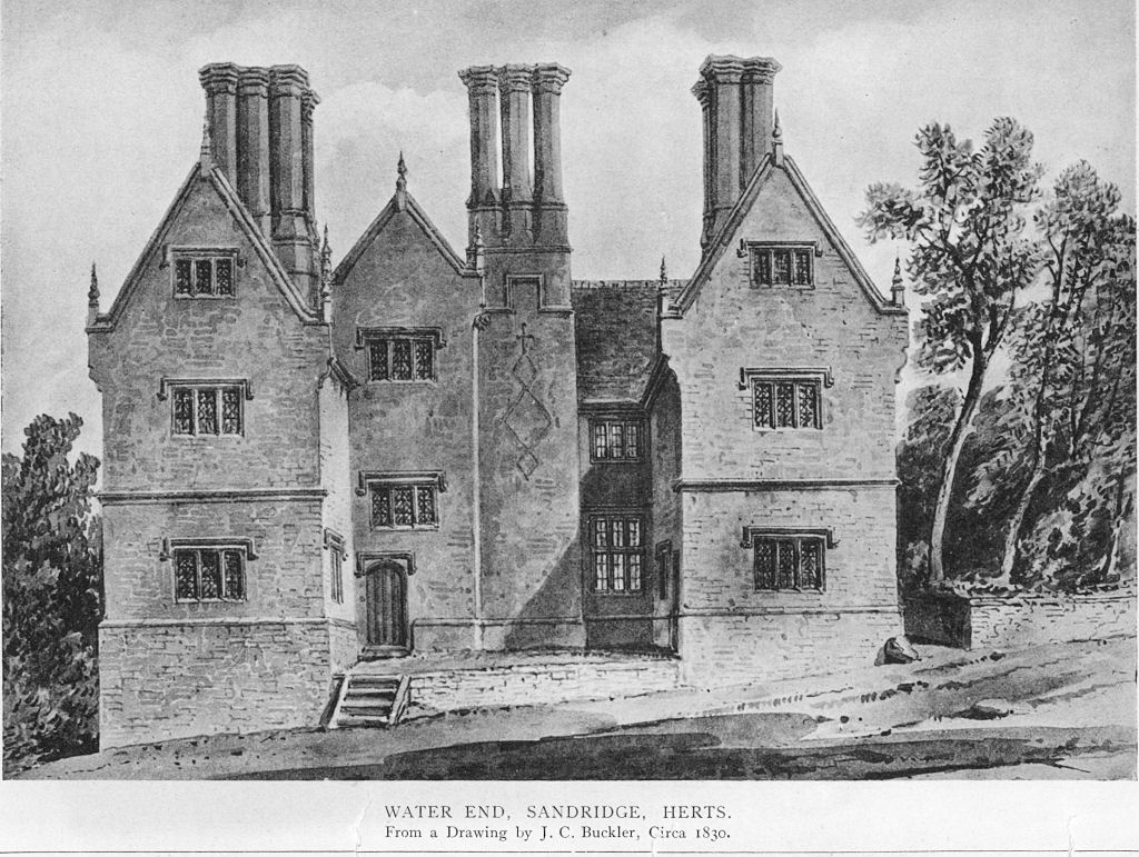
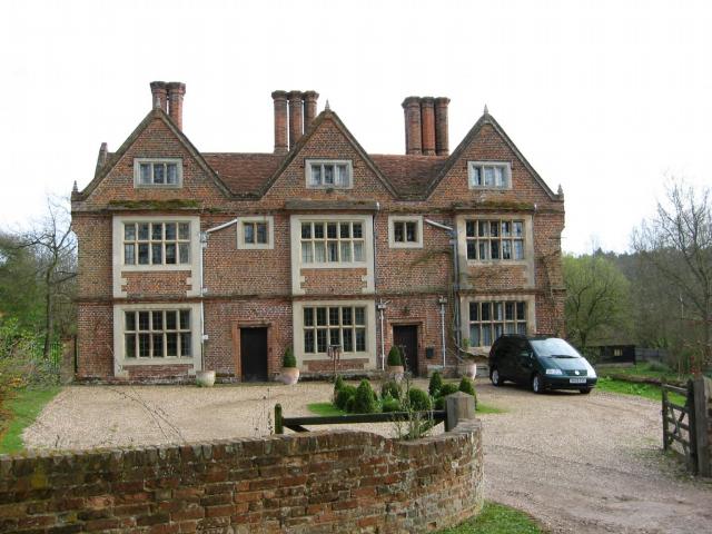
One of the most significant houses – Waterend House is a large Jacobean house which lies on the River Lea and was built in
1611 by Sir John Jennings aka Jennyns, Jenyns, Jenyngs (1596-1642) (Source 43) , a member of the Long Parliament for St Albans.
His daughter Sarah Jennings, (by his second wife Alice Spencer) who became the
First Duchess of Marlborough (1660-1744) was given the house.
The estate [located 24 miles from Hyde Park Corner in London] incorporates many historic features, among these are a
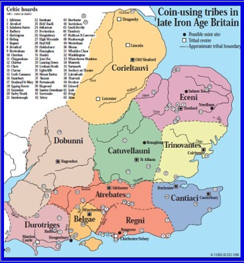
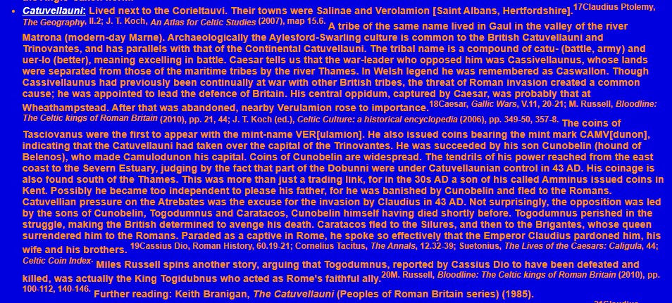
network of ironage earthworks. One of these, The Devils Dyke [in nearby Wheathampstead] is thought to have been the
capital of Cassivellaunus, who fought Julius Caesar in 54 BC.
The family are still actively involved in the management of the estate today. (See Source 39)
Webmaster's Note:
[David KC COLE, writes:] My grandfather, Charles (Charley) Percy COLE (1884-1966),
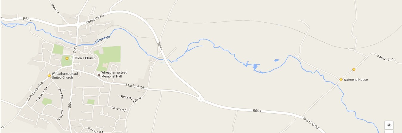
was born and raised at Waterend House, located 1.5 miles east of the center of Wheathampstead, Hertfordshire, England. (More
information and pictures are presented later in this article.) His father, James William
COLE (1851-1923), rented WaterEnd farm from the Brocket Estate. At that time, the Brocket Estate was
owned by the 7th Earl of Cowper (1834-1905), the great-grandson of William Willoughby Cole (1736-1803) [fsid: L1QB-D18]. The
relationship (if any exists) between James COLE and the wealthy William Willoughby COLE is unknown.
Charley always claimed that his ancestors included a Lord Mayor of London. In his book,
Coles of Devon (Source 7, publ. 1867) James Edwin-Cole includes William Willoughby Cole and
identifies numerous Lord Mayors of London in his family tree.
The ancient church, St Helens church in Wheathampstead, 1.5 miles West of WaterEnd House, includes the
graves of various persons named Cole, eg Leslie COLE (1903-1982), who are related to the webmaster, David Cole.
This church was named after St Helen, the mother of Constantine, the Great. Some historians claimed (in error)
that St Helen was princess Helena (Sources 8 and 9), the daughter of Old King Cole, himself. Source 9 is a
children's story based on a biography of this fabled Princess Helena. This story, a fable, was written by
David KC Cole, the webmaster of this site.
(To enlarge .....Click it)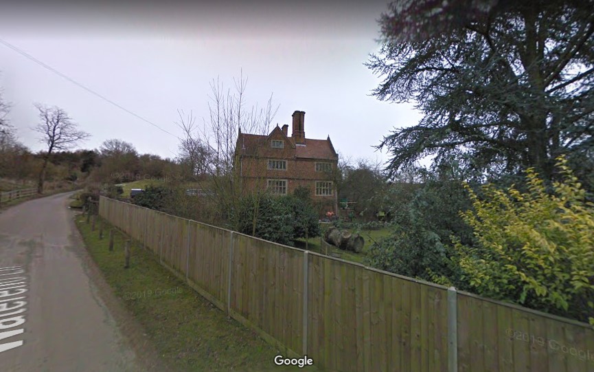 Winter View of WaterEnd House from the West on 2009 Feb |
(To enlarge .....Click it)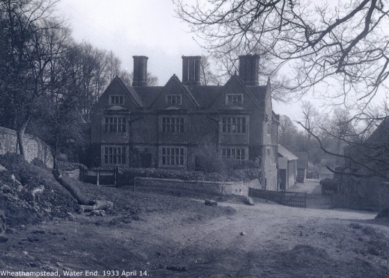 Winter View of WaterEnd House 14 April 1933 |
Waterend House: It is situated in Sandridge, Hertford, England (at postal code AL4 8EP) on Waterend Lane, just north of the
bridge (formerly a ford) where the ancient roman road crosses the river Lee.
Many more pictures of WaterEnd House and the surrounding area can be found at (Source 21 ) Water End House, Sandridge Pictures.
The Google Map location named "Waterend House Wheathampstead" shows the following text.
It is situated just north of the place where the ancient roman road crosses the river Lee. An ancient homestead in the parish is Waterend. In the time of King John, Thebridge, now known as Waterend, was held by Viel de Thebridge, a free tenant of the abbot of St. Albans. It is believed that the builder of the existing house was Sir John Jennings, who built it in 1610. It is the oldest existing house in the parish. It is a good example of an early seventeenth century red brick house on an E-shaped plan. There are two storeys and an attic with large moulded brick string courses between the storeys. The roof is tiled. The west front has three projecting windows with stone mullions and transoms carried up to the attic, and above them are three steep, straight gables, with moulded coping. At the back are three large chimney stacks, with groups of octagonal shafts, which nave moulded bases and caps. The inside of this private house is now much altered, but in the kitchen there is a wide arched fireplace, and there is an original winding oak staircase of plain character. [More info at http://www.ePhotoCaption.com/a/35/35.html ]
An ancient homestead in the parish is Waterend. In the time of King John, Thebridge, now known as Waterend, was held by Viel de Thebridge, a free tenant of the abbot of St. Albans. The oldest extant document concerning Sandridge relates to Waterend, where in 1248 a conveyance of land was made. John Fitzsimon died in possession of a homestead and dovecote at Waterend in 1304. He rented the property from the nuns of Sopwell in St. Albans, from whence the supposed authoress of the famed "Boke of St. Albans" was reputed to hail. Fitzsimon paid partly in money and partly by aid to the abbot of St. Albans. The manor then remained in the possession of the Fitzsimon family for a hundred years. When in 1437 Elizabeth Fitzsimon married Thomas Brocket, the Brockets were to hold the manor until 1590. This family was prominent in the neighbourhood, as the memorials in Wheathampstead church testify. As happened to nearly all the land in the parish, the manor passed to the Jennings family. It is believed that the builder of the existing house was Sir John Jennings, who built it in 1610. It is the oldest existing house in the parish. It is a good example of an early seventeenth century red brick house on an E-shaped plan. There are two storeys and an attic with large moulded brick string courses between the storeys. The roof is tiled. The west front has three projecting windows with stone mullions and transoms carried up to the attic, and above them are three steep, straight gables, with moulded coping. At the back are three large chimney stacks, with groups of octagonal shafts, which nave moulded bases and caps. The inside is now much altered, but in the kitchen there is a wide arched fireplace, and there is an original winding oak staircase of plain character.
The estate derives its name from the word Ayot, which is particular to Hertfordshire and means a high place, an island between two rivers.
AYOTT, ST. LAWRENCE, a par. in the hund. of Broadwater, Herts, 8 m N. from Hatfield, and 27 from London; containing 24 ho. and 160 inhab. It stands between the rivers Lea and Kempton. The church was rebuilt in 1779, by Sir Lionel Lyde, the patron of the rectory, which is valued at 8l, 13s , 4d.From the above we should deduce that the Ayot Estate is named after the high piece of land between the rivers Lea and [erroneously] Kempton. However, modern descriptions of Ayot St. Lawrence indicate that it is near the River Mimram that joins the River Lea at Hertford. Furthermore Google Maps does not list any River Kempton. Closer examination of Google Maps in that area show that a village named Kimpton exists near the River Mimram and a Kimpton Road follows the River Mimram. The conclusion of the webmaster is that Source 41 should have said that Ayott St.Lawrence stands between the rivers Lea and Mimram [not Kempton]. Perhaps the names have changed over the years. The "dated" river name and the "dated" spelling of the town in Source 41 were misleading. Many such minor errors (or ancient nomenclature) exist in books. They do not mean that the whole book is wrong.
AYOT, ST. PETER, 3 m. distant from the former, nearer Hatfield; containing 50 houses and 233 inhabitants. It is a rectory, value 7l, 8s, 6d.
[E_Cole5H17.GED]The following descent was created based on information provided by June (or Jane) Munday:
[Cole5H17.GED]
DC0001 SOURCE=FTREE# 86 Born in Hawnes,Beds., (also spelled Haynes, Bedfordshire), south of the city of Bedford. Les COLE (and his daughter Ann) say that some older COLES are buried in St Helen's churchyard, but I have not seen their gravestones there. Presumably the older COLEs buried there are Daniel COLE and his wife Emma COLE. /DC0001
DC0075 On 24 Oct, 1984, Irene JEZEK writes "At the census office, I found that Daniel COLE owned Chase Farm from 1851 (or before, not in 1841) up until 1881 Census (and possibly later). /DC0075
DC0069 I [David COLE b. 1944] have since looked Daniel COLE up on the 1881 census. I found Daniel, Emma and three of their sons, Alfred, Bertie and Edwin. All the sons were born in Barnet, Middlesex, and Emma's place of birth was Cotton End. The family was living at Chase Farm, South Mim[m]s, Middlesex. Daniel was a farmer of 250 acres employing 3 men. I also noted that the following persons were also residing at Chase farm at the time of the 1881 census: Eleanor GRAHAM age 54, b. Thurton Le Feuer, Lincoln, England Occupation: housekeeper Albert HART age 17, b. Halstead, Essex, England , Occupation: labourer Ellen HOWARD age 14, b. P Bar, Engand, Occupation: visitor /DC0069
DC0167 The following notes compiled (from source 37) concerning William Gutteridge BRIMLEY (1786-1867) mention Daniel COLE and his son James W. COLE. William left Huntingdon, Beds and went to work for a Mr. COLE [Daniel Cole(1820-1898) fsid: L6NP-XG7 ], a London business man who owned a farm [Chase farm] on the outskirts of Potters Bar. It seems more than a coincidence that the three of them went to live in the same district. Mr Daniel COLE had a son [James W. COLE (1851-1923)] who became a tenant farmer at Water End, Wheathampstead, Herts. The property belonged to the Earl COWPER of Panshanger Park. (Welwyn Garden City now stands on the site and Panshanger Hall has been demolished.) William was offered a job there and moved to Water End where he went to lodge with. . . Maria CHANDLER, who was born at Cromer Hyde near Lemsford, Herts on 5th September 1857. The next note (by source DC0075 which is the England census 1871) does cite an Emma BRIMLEY living with Daniel COLE and Emma (Nee COLES) in 1871. This adds much credibility to these notes by source DC0167. Refer to a subsequent note by DCole (Source DC0001) where John BRIMLEY is the grandfather of William Gutteridge BRIMLEY (1786-1867) is also the great-grandfather of Daniel COLE (1814-1898). They do not share a common grandmother because John BRIMLEY (1715-1780) had more than one wife. Two wives of John BRIMLEY make Joseph BRIMLEY (b. 1760) the step-brother of Sarah BRIMLEY (1763-1788). If it were not for the two wives, Emma BRIMLEY (b. c 1842) would be a true niece of Daniel COLE (1814-1898). /DC0167
DC0075 At the time of the 1871 England Census (source DC0007), Emma BRIMLEY was living with Daniel COLE and Emma COLE. The census entry was: Emma Brimley niece 30 Housekeeper b. Willington, Beds. The exact census reference code is unknown because it was not recorded by source DC0075 (B.Warren). For more information about the relationship between Emma BRIMLEY and Daniel COLE, see the following note by source DC0001 (DCole). /DC0075
DC0001 I was intrigued by the Emma BRIMLEY who was living with Daniel COLE during the England Census of 1871. So I searched for a "direct" "niece" (of Daniel COLE) named Emma BRIMLEY. Taking "niece" to mean "daughter of a sibling", no Emma BRIMLEY was found to be a niece of Daniel COLE. In fact, the closest "niece" of any kind that I could find was the daughter of William BRIMLEY (b. 1817). This was before I had discovered Mary SAVAGE and her descendants. (The part of the descent below "Note 7" had not yet been added.) The relationship is shown below (where "=" or "x" means marriage):
    Ann HICKLEY (c1729-1756)        =         JOHN BRIMLEY    =   MARY JONES (1728-1807)       Note 6
    --Joseph BRIMLEY (b. 1760)                 (1715-1780)        --SARAH BRIMLEY (1763-1788)
      x Jane GUTTERIDGE (b.1762)              FSID:L4TQ-5NH         x THOMAS COLE (b.bef.1759)
        --William Gutteridge BRIMLEY (1786-1867)                      --JAMES COLE (1783-1851)
          x Peggy FARR (c1790-1863)                                     x MARIA LINE (c1782-aft.1851)
            --William BRIMLEY (b. 1817)                                   --DANIEL COLE (1814 or 1820-1898) FSID: L6NP-XG7
              x Unknown                                                     x EMMA COLES (1821-1913)
                --Emily BRIMLEY (b. c1842)  Note 9                            --JAMES W. COLE (1851-1923) Note 7
            --Charles BRIMLEY (b. 1814)                           --James BRIMLEY (1773-1838)
              x Sarah Mercy TWITCHELL (b.1826)                      x Mary SAVAGE b1775   FSID: KN4J-77R
            -- 9 other siblings                                       --Eli BRIMLEY (1808-)
                                                                        x Sarah b1814
                                                                      --John BRIMLEY b1804 Cople
                                                                        x Elizabeth Anne COLE b1816 Cotton End  FSID: MMJ2-6N7 Note 8
                                                                          --Emma BRIMLEY b c1841  Note 9  FSID: MMJK-36X

Note 6: John BRIMLEY had a third wife named Elizabeth WILLAMOT
Note 7: JAMES COLE and his ancestors have their given names capitalized to show that they are my direct ancestors
Note 8: How is Elizabeth Anne COLE related to my COLE family, if any relationship exists?
         Ancestry (Source 36) shows that she married John BRIMLEY on May 31, 1836 in Willington, Bedfordshire.
         Unfortunately Source 34 for Marriages in Willington, Beds begins the very next year in 1837.
         Elizabeth Anne COLE is the daughter of Thomas COLE (1790-) and Mary. Parents of Thomas COLE are unknown.
Note 9: The question is: Is Emily BRIMLEY b c1842 or Emma BRIMLEY b1841 the person lving with Daniel COLE in 1871?
William Gutteridge BRIMLEY (above) can be found as father of a groom in Willington, Beds. in Source 34.
Using English phraseology we have two possibilities:
Case 1:
"Daniel COLE's grandmother Sarah BRIMLEY was the step-sister of Emily BRIMLEY's great-grandfather Joseph BRIMLEY". The step-sister relationship occurs because John BRIMLEY (1715-1780) was married to Ann HICKLEY in 1760 when son Joseph was born. John BRIMLEY (1715-1780) was married to Mary JONES in 1763 when daughter Sarah BRIMLEY was born. The Emma BRIMLEY (b. c1841) in the Census of 1871 (who was living with Daniel COLE) could be Emily BRIMLEY who was mentioned by source DC0167, to be a descendant (or daughter) of William Gutteridge BRIMLEY (1786-1867). But only if Emma is a diminutive name for Emily. Indeed, Emily BRIMLEY (b. c1842) is one generation younger than Daniel COLE and Emma COLES.
Case 2:
"Daniel COLE and Emma BRIMLEY (b1841) are second cousins having identical great-grandparents (JOHN BRIMLEY and MARY JONES). In this case, Emma BRIMLEY (b1841) would be in the same generation as Daniel COLE. The exact wording of the 1871 Census entry was:
Emma Brimley niece 30 Housekeeper b. Willington, Beds. . . . Census 1871
CONCLUSION:
Clearly, this above line of the 1871 census report was wrong. Either Emma's name should have been written "Emily" or the relationship should have been "second cousin" instead of "niece". In 1871, the age of Daniel COLE was 57, so most people would consider Emma (age 30) to be a niece rather than a cousin of his same generation. The author, David KC COLE, believes June Munday who affirmed this same conclusion without question when she wrote to David Cole (see the 3rd decent below). The conclusion of David COLE as of 2019 J Oct 29 is that:Emma BRIMLEY (b1841) was indeed the second cousin (not the niece) of Daniel COLE.
***************************************************************************
The first William BRIMLEY (1842-1899) and his descendants are not yet listed in the davidcole3 database because their relationship to the author (David KC Cole) was not known prior to Oct 2019. The WebMaster's tree at Ancestry has been updated. The descendancy, that of William BRIMLEY (1842-1899, is as follows:James BRIMLEY 1773-1838 FSID: KN4N-NQ3 x Mary SAVAGE b1775 FSID: KN4J-77R --Eli BRIMLEY b1809 FSID: LTKR-BZZ x Sarah b1814 --James b 1841 --John b 1847 --Joseph b 1849 --Frances BRIMLEY b1851 x ? BIRD --John BB BIRD b1859 FSID: G3D5-HF9 --Eli BRIMLEY Jr Note 5 --William BRIMLEY (1842-1899) FSID: 9KZS-CWQ x Maria CHANDLER (1857-1950) FSID: 9KZS-C4D --William BRIMLEY (1878-) --Lillian BRIMLEY (1881-1902) --Herbert (Bob) BRIMLEY (1883-1979) x Margaret TROTT (-1967) --George (Bob) H. BRIMLEY (1921-) NB The researcher. x Eileen M. FRY --Robert George BRIMLEY (1943-) NB Source DC0167. x Sandra SNATCHEL --Lindsy BRIMLEY (1974-) --John BRIMLEY (1886-1888) --Lucy BRIMLEY --Charles BRIMLEY (c1880-c1880) Note 5: Eli BRIMLEY Jr may not existNote that none of the descendants of the Eli BRIMLEY (mentioned above) appear in this database as individuals. Recent work has now (as of Oct 2019) linked all 3 descents. Mary SAVAGE now appears in all 3 of the above descents. The author has now linked together all 3 descents by modifying the FamilySearch database (although many duplicates remain). For more information about the BRIMLEYs mentioned in this note, see the notes attached to William Gutteridge BRIMLEY (1786-1867) in the davidcole3 database. The above Herbert BRIMLEY (and his Mother's CHANDLER ancestors) can be found in Source 33 in a WorldConnect database by Matthew HUDSON. /BrimleyEmma.rtf /DC0001
  Emma BRIMLEY b c1841
  was living with
  Daniel COLE b1814
  during the Eng. Census of 1871

  1 Thomas BRIMLEY
  ..m Elizabeth ?
  ....2 Samuel BRIMLEY
  ......m Elizabeth TENNANT 1689-1760
  ........3 John BRIMLEY b c1715
  ..........m Mary JONES b 1729 Cople
  ............4 Sarah BRIMLEY b 1759-1788
  ..............m Thomas COLE b 1759
  ................5 James COLE b 1783
  ..................m Maria LINE b c 1782  FSID KC48-631
                         BEWARE may be a different Mary FSID: KH6J-CV8  Note 4
  ....................6 Daniel COLE b 1814-1898
  ......................m Emma nee COLES b 1821-1913
  ............4 James BRIMLEY b c1773             FSID: KN4N-NQ3
  ..............m Mary SAVAGE b 1775 Cople m1803  FSID: KN4J-77R
  ................5 John BRIMLEY b1804 Cople      FSID: MMJ2-6FT m 31 May 1836 Willington, Beds.
  ..................m Elizabeth Anne COLE b1816   FSID: MMJ2-6N7 b:Cotton End
  ....................6 ?Marianne BRIMLEY b 1837
  ....................6 Emma BRIMLEY b c1841
  ....................6 ?Harriet BRIMLEY b 1842   FSID: G3D5-4HJ
  ....................6 ?Sarah BRIMLEY b 1844
  ....................6 ?Elizabeth BRIMLEY b 1846
  ....................6 ?Charles BRIMLEY b 1848
  ................5 Eli BRIMLEY b1808     FSID: KH8T-M4Q  & LTKR-BZZ
  ................5 Levi BRIMLEY b1811    FSID: KZ8Q-Y9S


  Emma BRIMLEY (b c 1841) and Daniel COLE (b1814)
  had common great-grandparents named
  John BRIMLEY (b c1715) and Mary JONES

  Source: Jane Munday email to David Cole in 2???
  Note 1: The PostEm at worldconnect was lost so
          the above has been recreated with current
          dates (by David KC Cole in 2019 J Oct 27).
  Note 2: All of the above people have been
          entered into the FamilySearch database.
  Note 3: Generation 6 names with "?" were found
          in FamilySearch in 2019.
  Note 4: Maria LINE and Mary might be different people
               Mary       KH6J-CV8  & James COLE LYW1-1PZ
            or Maria Line KC48-631  & James COLE LYW1-1PZ
            or Maria      MMLJ-Y5Y
  Note 5: the identifiers preceded by FSID: are FamilySearch identifiers.

  /saved with article 35
  /BRIMLEY_Emma_bc1841.txt
(To enlarge .....Click it)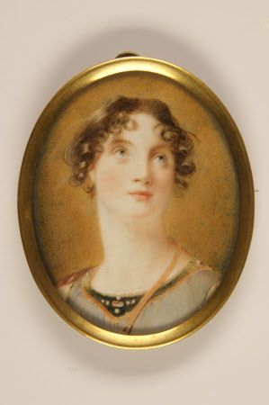
Lady Henrietta Frances Cole (1784-1848) |
(To enlarge .....Click it)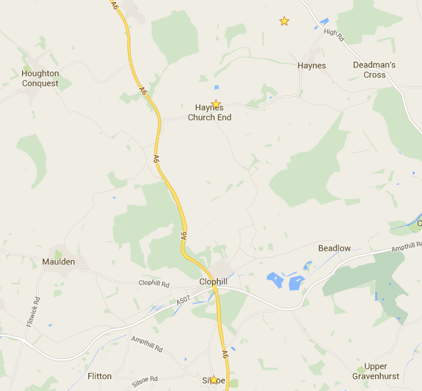
Map: Haynes (And Silsoe) width:6 km |
(To enlarge .....Click it)
The Gardeners Chronicle..1902 |
The wealthy William Willoughby Cole (1736-1803), mentioned previously, is the grandson of the famous John of Florence-court COLE (1680-1726). John built the grandiose castle in Ireland, shown below, to commemorate his wife, Florence Wrey. More information about John of Florence-court can be found at Source 13. The magnificent house on the right is called Wrest House (Source 18), the manor of Wrest Park. It was designed by Thomas Phillip WR de Grey (1781-1859) and built in 1834-1839. He and his wife, Henrietta Frances Cole, lived in Wrest Park in their latter years. Henrietta Frances Cole was the wealthy daughter of William Willoughby Cole. Imagery associated with Google Maps provides an amazing 360 degree Photo-Sphere of the front yard of Wrest Park (and from other points of view). Within Google Maps, search for "Wrest Park, Luton, United Kingdom" (Source 35). This mansion replaced an older but equally impressive house that existed prior to 1708.
(To enlarge .....Click it)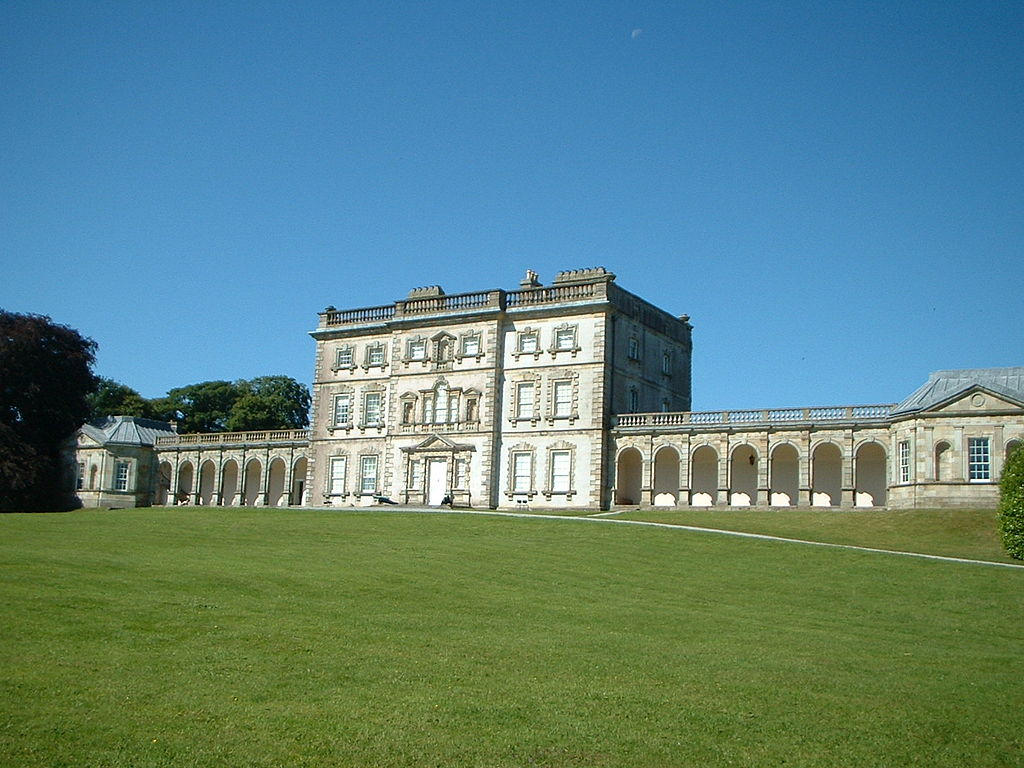
Florence Court |
(To enlarge .....Click it)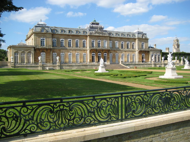
"WrestHouse3" by Nigel Cox. Licensed under CC BY-SA 2.0 |
Both photos (below) are of Waterend Barn before it was relocated. The photos were taken from the south bank of the River Lea.
(To enlarge .....Click it)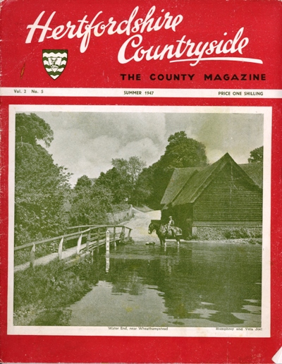 WaterEnd near Wheathampstead Summer 1947 |
(To enlarge .....Click it)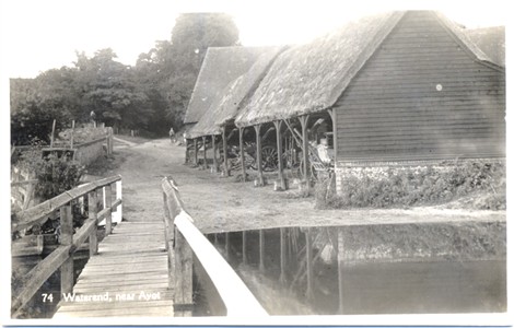 Waterend House Barn |
Shown below, on the left, is a map of the Brocket Hall area. More is said about the Brocket Hall and Brocket Estate later in this article.
In the top left corner of the map, the road between James's Wood and Marford Rd is Water End Lane. This very straight lane
running NorthEast from the city of St. Albans to Welwyn (and beyond) is purported to be an ancient Roman road. [In Roman times the name
of St.Albans was Verulanium.] Travelling SouthWest, after Water End Lane
crosses Marford Road, its name becomes Coleman Green Lane. The name Coleman Green probably has no connection to the
family of James William Cole who inhabited Waterend House around the year 1900. Waterend House is just North of the point
where Water End Lane crosses the river Lee (also called the River Lea). Travelling NorthEast after crossing the river Lee, Waterend House
is on the East side of the lane. Wheathampstead is about 1.5 miles West along Marford Rd (now B653). At the time when Charles
COLE was living in Waterend House (circa 1901) as a child, Brocket Hall was a manor, not a Golf Club as it is now in 2014. In
1907 Charles Cole emmigrated to Canada where he settled in Moose Jaw, Saskatchewan.
Welwyn lies to the North East a few miles North along the A1(M). Nearby, South-West of Waterend House, on the South
bank of the river Lee, another famous house is located. It is called White Cottage.
To use GoogleMaps to view the Brocket Hall area: Click Here. The exact coordinates of Brocket Hall are: 51°48'09.9"N 0°14'25.5"W.
Click here: Waterend House to view Waterend House using GoogleMaps Street View. Many photos of the immediate area are also available here, including a photo of White Cottage.
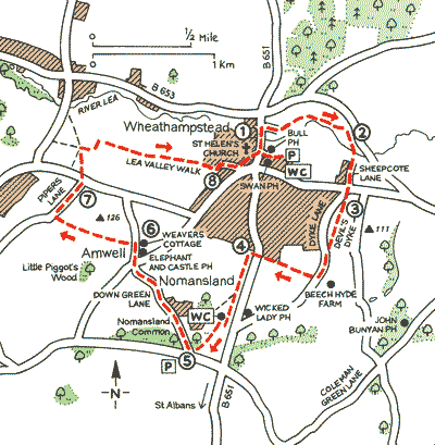
There are many walking paths in the area. One well-known path is the Lee Valley Walk along the River Lee from Leagrave to the Thames river. An entrance to this path going NorthWest is about 15 meters south of the entrance to Waterend House. This portion of the walk, heading south, is described as follows:
"The path descends into the Lea Valley, passing under the railway lines before crossing the B653 [Marford Road]. The route now follows the track of a disused railway, the former Luton, Dunstable and Welwyn Junction line. After Harpenden the path leaves the railway track and heads uphill into Wheathampstead, then it goes through the village, past the church, and crosses over to the other bank of the river. The path now follows the river towards Water End Lane and the grounds of Brocket Hall where it crosses the middle of a golf course on its way towards Lemsford. The path goes under the A1 road to Stanborough Park."
The river Lee continues Eastward through Welwyn Garden City to the city of Hertford where the river Lee canal system begins. Barges and river boats can follow the Lee Navigation system which leads to the Thames river.
(To enlarge .....Click it)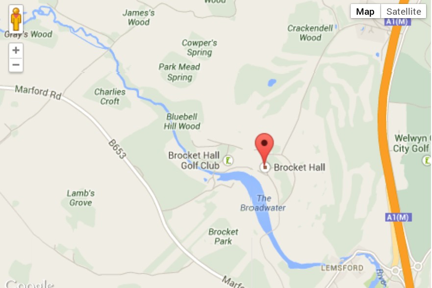 Map of Brocket Hall area |
(To enlarge .....Click it)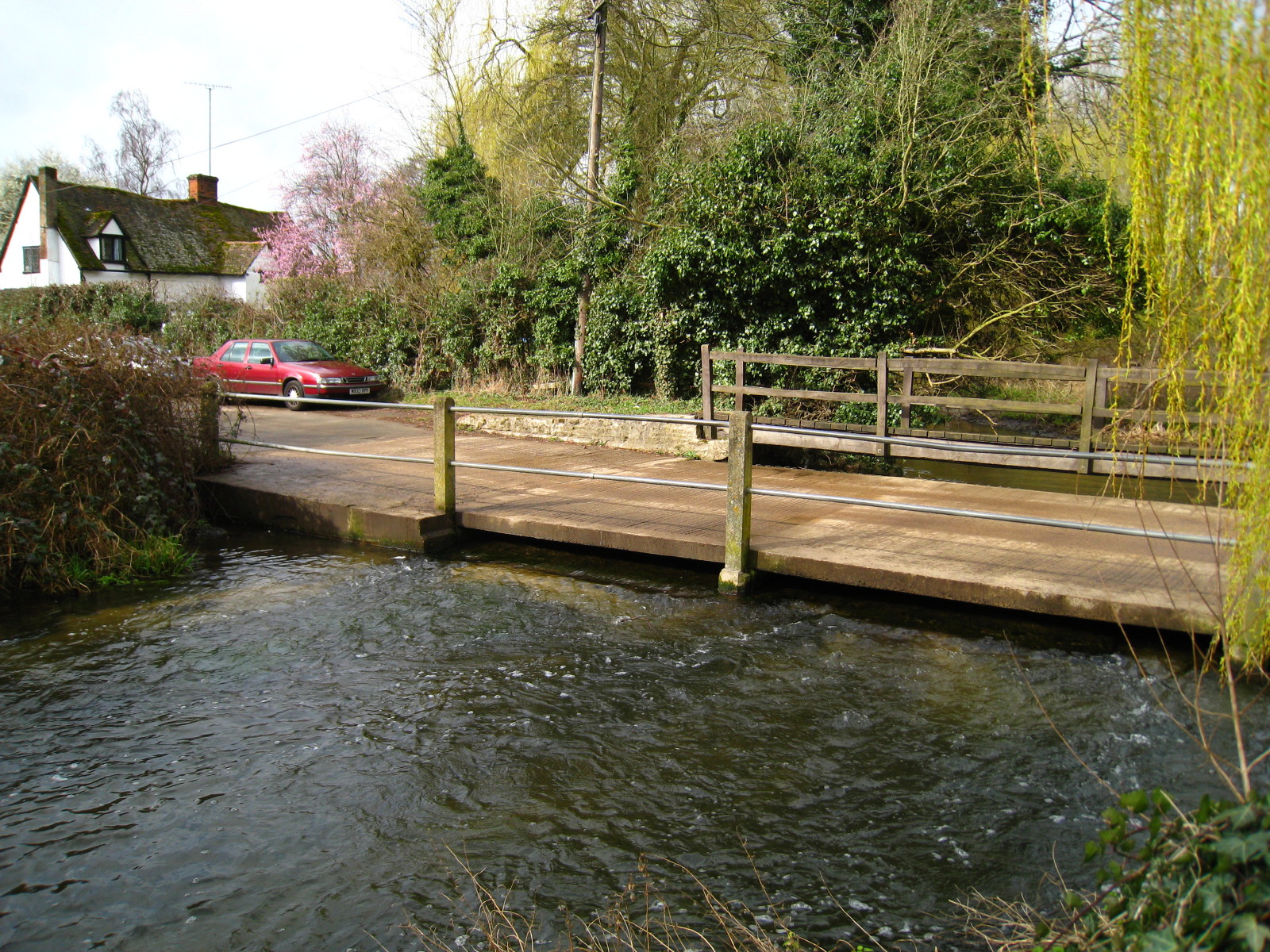 Bridge across the Lee |
(To enlarge .....Click it)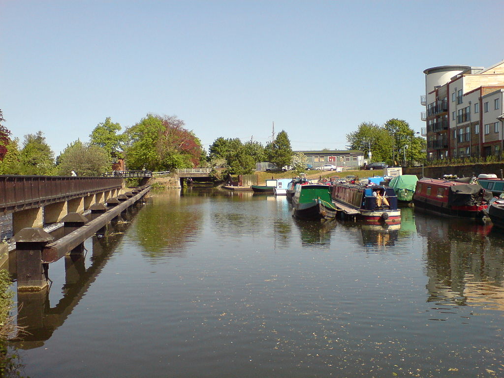 Hertford Basin |
The photo (above center) of the bridge across the Lee was taken from the Waterend House side looking SouthWest. The White Cottage can be seen in the top left corner of this photo.
James COLE rented Waterend House and Waterend Farm from the owner or tenant of Brocket Estates.
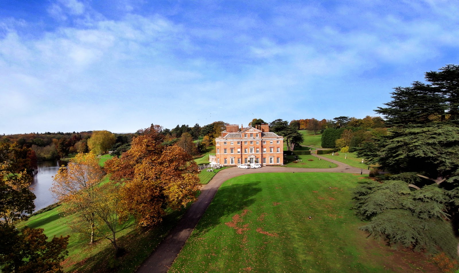
Between 1893 and 1921 the manor house at Brocket Hall was rented and one of its residents was Lord Mount Stephen
who was part of the consortium which built the Canadian Pacific Railroad. Brocket’s tradition for excellent
entertainment, and ample opportunities for shooting attracted him. The photo of Brocket Hall Manor below
shows how grand the estate is. Brocket Hall is located where the river Lee is the widest. This is not
by accident. Apparently, a dam was built on the river Lee in order to create the BroadWater by
the Manor. Of course, this raised the water level of the river Lee making it more difficult to cross
the river near WaterEnd House. For this reason, a foot-bridge was built for pedestrian traffic.
Eventually, a vehicle bridge was also built permitting WaterEnd Road to cross the river.
If the trees were removed from the photo of the Manor, WaterEnd House would be on the horizon near the
right hand side of the photo.
On the left (below) is a photo of Waterend House in 1904 at the time when Charles COLE was living there as a child. An enlarged view of this postcard shows a man facing us, with his back to the front door. Probably he is my great-grandfather, James William COLE shown below. On the right of this photo, a portion of the WaterEnd Barn (now relocated) can be seen. The former barn area has now become a wide area of lawn and garden.
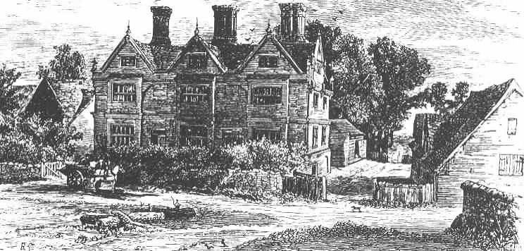
Below, on the right, is an earlier photo (1895) of a drawing from Source 45, showing the West side of WaterEnd House. This side is rarely seen due to the many deciduous trees on that side of the house.
(To enlarge .....Click it)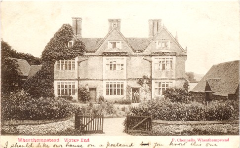 Waterend House (1904) |
(To enlarge .....Click it) Waterend House (1895) |
(To enlarge .....Click it)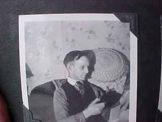 Charles (Charley) COLE (1884-1966) |
(To enlarge .....Click it)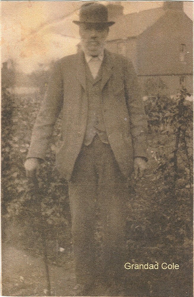 James William COLE (1851-1923) |
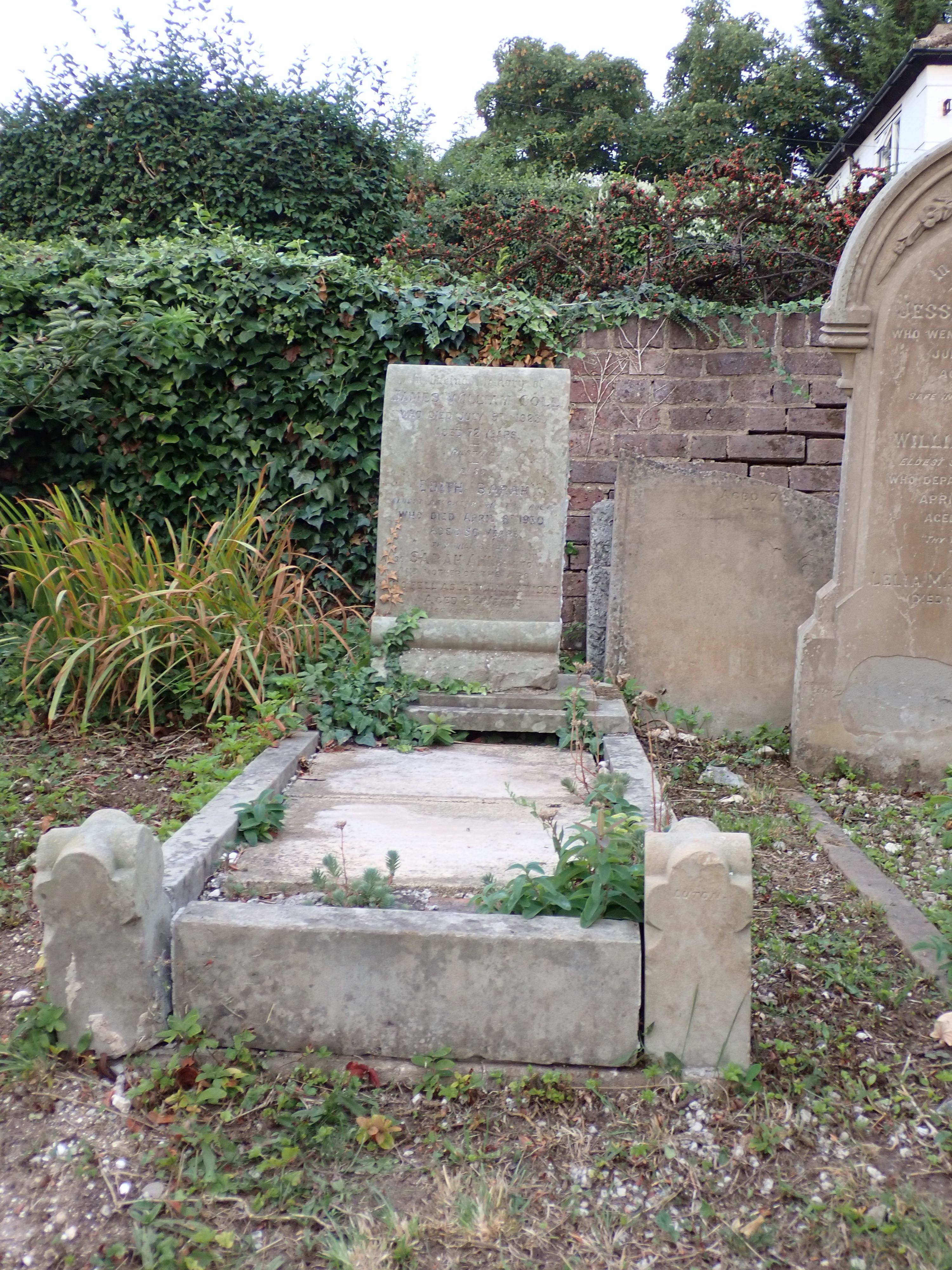
(To enlarge .....Click it)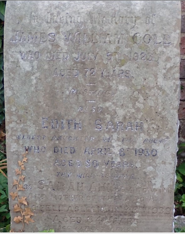 Actual gravestone of Cole James W in 2022 |
Charley's first home, Water End House, is located about 1.5 miles east of Wheathamstead, where a small bridge permits the ancient Roman road (now called Waterend Lane) to cross the river Lea. In earlier days before the bridge was built, travellers along the Roman road would ford across the river at this location. The height of the river Lee was raised here when the lake was created in front of the Brocket Manor. The lake was created by building the equivalent of a small dam.James William COLE (1851-1921)
Additional information is available at the author's web site ColeDavid.com. Other photos and more of the history of Water End Farm can be found at Source 10.
Water End House has been maintained in very good condition until at least the 1990's when the author last visited it. The census of 1881 lists his father, James COLE, but does not list Charles, indicating (of course) that he was born after 1881. The census of 1885 shows that the infant Charley, his parents and the rest of their family were living in WaterEnd House in Sandridge. One day, by accident, Charles was severely burned inside WaterEnd House near one of the fireplaces. The left side of his face was noticeably scarred and his ear was burned almost completely off. He could still hear well with the disfigured ear. However, in time, he became quite deaf in the other ear.
In the census of 1885, Charles COLE is shown to be living at Water End Farm near Sandridge, Hertford, England. Herbert BRIMLEY, a childhood friend of Charley's is also mentioned in this census [1885]. Herbert's father, William BRIMLEY (1842-1899) was employed by Charley's father, James COLE at Water End farm. A neighbor, Willm BRIMBY, age 32, is listed in the 1881 census, but this is probably a different person although the pronunciation of the two surnames is very similar.
Charles was born at Water End House in Sandridge, Hertford, England near Wheathampstead. Charles left Wheathampstead, England (a few miles north of St. Albans) around 1907 to emigrate to Canada where he settled in Moose Jaw, Saskatchewan. Florence KINGSLAND, a childhood friend of his, also from England, also emigrated to Canada around the same time. Eventually, they were living together and purchased a home in Moose Jaw at 1027 Ominica St. E. where both their children, Gladys (1914-2003) and Victor (1918-2010, were born. No record of their official marriage has been found. But Florence nee Kingsland COLE was married to a Herbert Edward Johnson in England in 1904. No record of a divorce was ever found. Florence moved to Canada shortly after separating from him. When Vic was a child, his parents invited an orphan, living next door, Art WOOLGAR (1908-c2000) to live with them. For the six years that Art lived with them, Vic learned much from Art, whom Vic considered to be like an older brother. Note that Art was 10 years older than Vic and 6 years older than Glad.
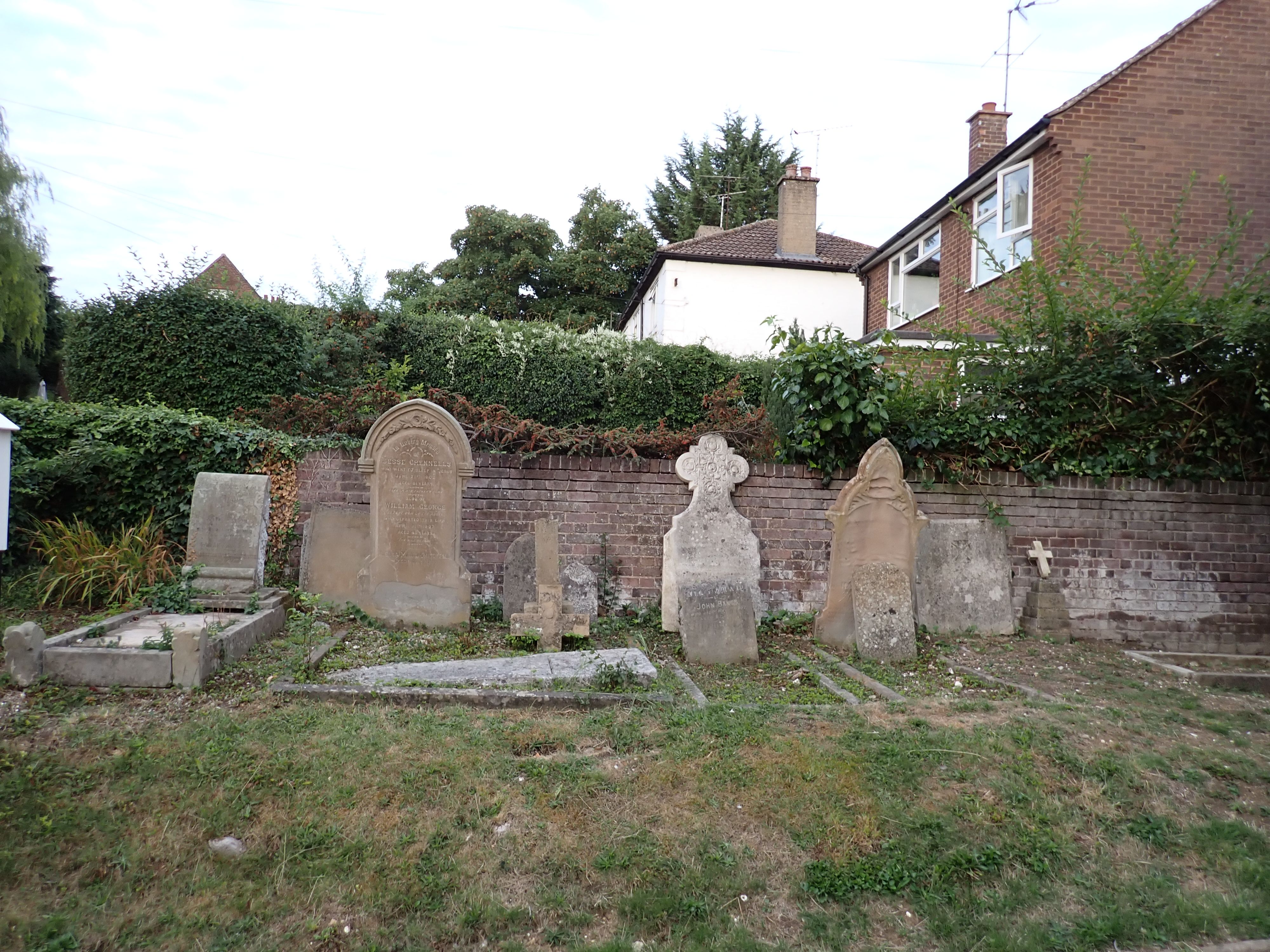
As of 2022, the gravestone of James William COLE can be easily found. Forscher photographed it in 2022 and wrote:
If you stand in Brewhouse Hill and face the front of the church the stones are all on the left hand side in the area in front of the church arranged perpendicular to the front face of the church. I believe that that the property behind the wall in the photograph is number 24 Brewhouse Hill - if you zoom right in on Google map the house next door is marked as 24. There is no back yard to the church as this is taken up by the Chapel Halls. The church itself is currently no longer used.
The grave of James William COLE appears at the extreme left of the photo below:
(To enlarge .....Click it) The Bull Pub in Wheathampstead |
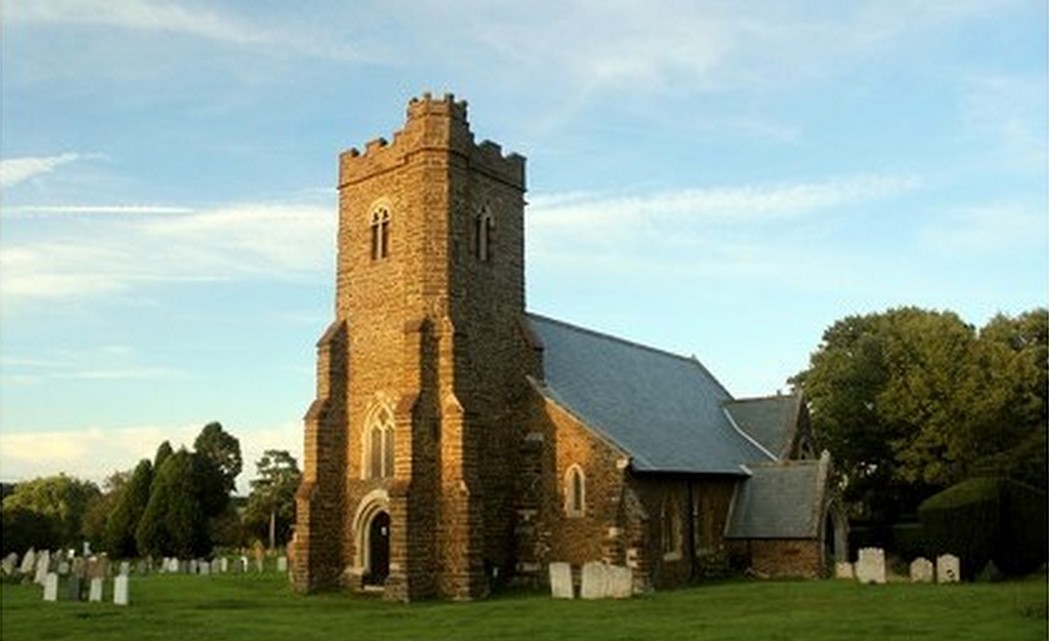
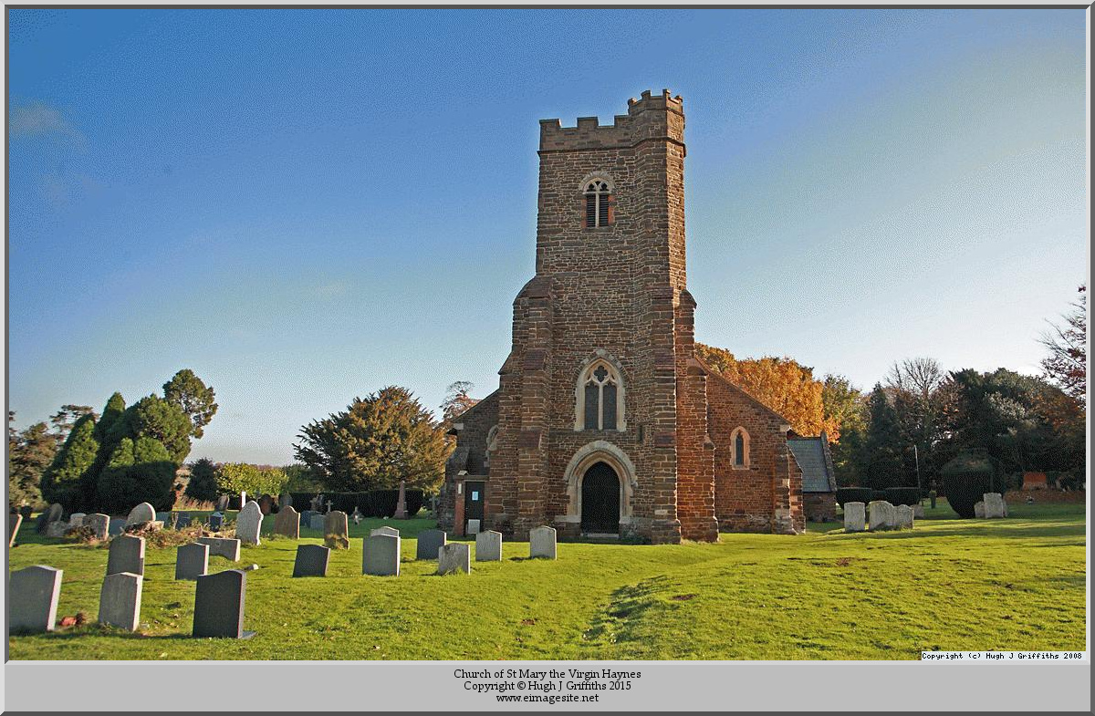
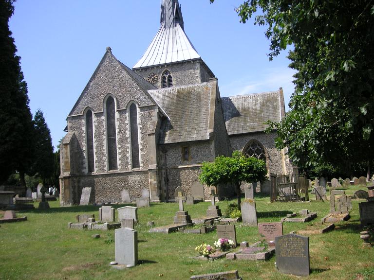
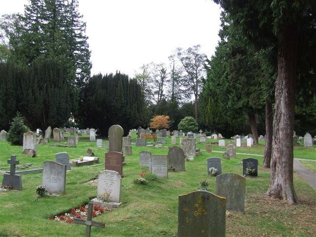
(To enlarge .....Click it)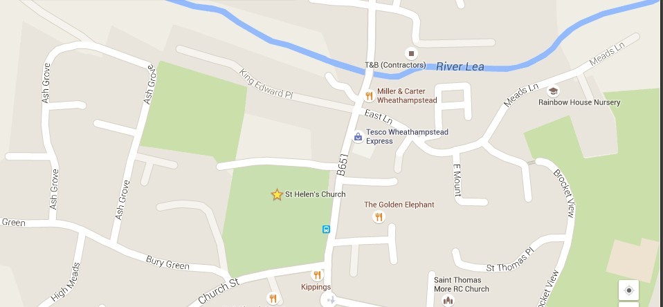 St Helen's church in Wheathampstead |
Wheathampstead means `homestead where wheat is grown`. Edward the Confessor granted the manor to Westminster Abbey, whose monks received wheat from here. The present mill, on the original site in the High Street, is 16th-century but with a Victorian brick frontage. St Helen's church was completed in 1340 and its unusual spire (likened to an upturned ice cream cornet and admired by John Betjeman) added in 1865. In the north transept there is a memorial to Apsley Cherry-Garrard, who found Captain Scott's body in the Antarctic in 1912. Cherry-Garrard lived at Lamer Park manor house where, influenced by his neighbour, George Bernard Shaw, he wrote an account of the British Antarctic expedition called `The Worst Journey In the World`. The Jacobean pulpit comes from Lamer Park's chapel.The Bull Inn [closed as of 2015, the photo above is by Frank Warner] is a Tudor building which has been an inn since 1617. Early guests include General Monck, who stayed during the Civil War and Izaak Walton, who fished all along the Lea.
The house at Water End Farm was built in 1610 for the grandfather of Sarah Jennings, who as Countess of Marlborough became a powerful member of Queen Anne's court. Sarah was born at the house in 1660, and here she and the young Princess Anne may have played together as children. Of Sarah's many houses only Water End and Blenheim Palace remain unchanged. The Water End Lane is on the line of a Roman road from Braughing, which was a Roman town and the junction for traffic passing between East Anglia and Verulamium (St Alban's).Turn right down the lane to a ford [across the River Lea]. Just before the water go left along a path. As the river disappears the way leads along the bottom of two fields with a fir wood on the hill to the left. There is a brief glimpse of the river (right) before the now narrow path meets a junction on the edge of the Brocket Estate. . . . . .
The photo below is a painting of "Hounds and Horses by The Bull Hotel, High Street, Wheathampstead 1902". It is signed E.F. Holt dated 1902. Notice the spire of St Helen's Church in the top right corner.
(To enlarge .....Click it)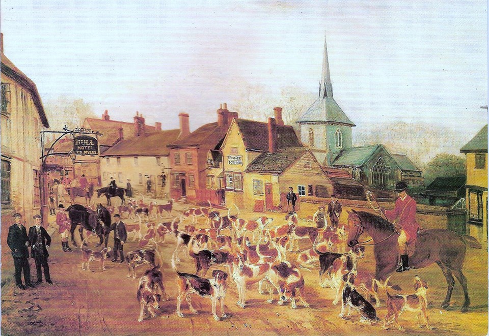
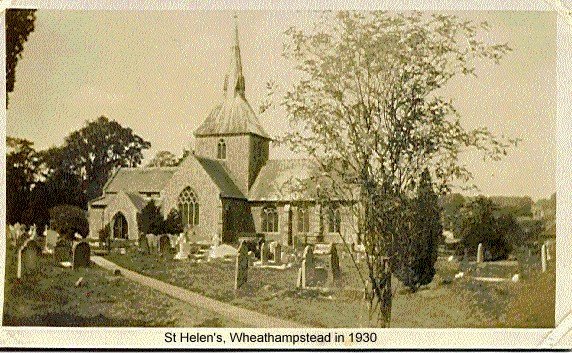
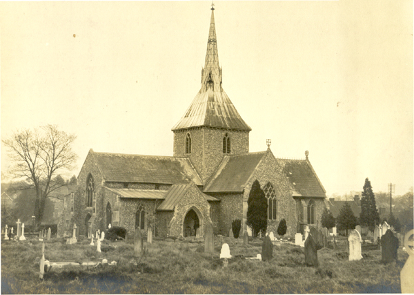
Many COLE ancestors are buried at St Helens Church in Wheathampstead, which is located about 1.5 miles West of Waterend House. The photo below of St Helens church was taken in 1930. David KC COLE, the author of this article, visited Waterend House for the first time in 1964.
It was Leslie COLE (the cousin of Victor COLE, David's father) who was kind enough to show David both WaterEnd House and St. Helens church for the first time. More information can be found about St Helens church here. It is said that the original church was built before the Norman conquest (which was around 1050).
The more ancient COLE ancestors came from Bedfordshire, many from the town of Haynes (formerly known as Hawnes). Daniel
COLE (1814-1898), the father of James William Cole (1851-1923), was born in Hawnes, Beds. Daniel Cole married Emma COLES
on 28 NOV 1848. Her maiden name was indeed COLES and she had a common COLE ancestor with husband Daniel. Daniel died on 12 May 1898.
Hawnes, Beds. is approximately 30 kilometers North of Wheathampstead, Herts. Haynes (also spelled Hawnes, Bedfordshire)
is located 10km south of the city of Bedford. The parents of Daniel Cole were parishoners of
St. Mary's Church at Haynes Church End, which is about 1 mile West of Haynes village. At the time, they occupied Hammer
Hill farm, which is located a mile or so North of Haynes.
Les COLE (and his daughter Ann) say that some older COLES are buried in St Helen's churchyard, but I have not seen their gravestones there. Presumably the older COLEs buried there are Daniel COLE and his wife Emma COLE.
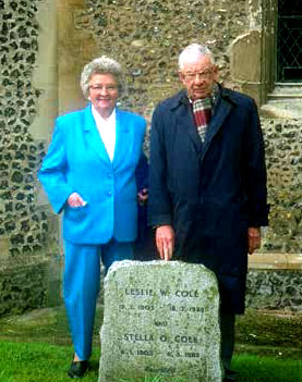
Leslie COLE [fsid: LKP9-HTR ] and his wife Stella O COLE nee SEABROOK [fsid: L7JP-Z5D ] are both buried at St. Helens. Further down in this article is a photo of my parents standing behind the gravestone of Leslie and Stella COLE. There was a reference at
Wheathampstead families that lists the inscription on their gravestone:
At St Helen's Church
Leslie W Cole/ 15.5.1903 - 18.2.1982/ and/ Stella O Cole/ 6.1.1902 - 6.3.1983/ "Reunited"
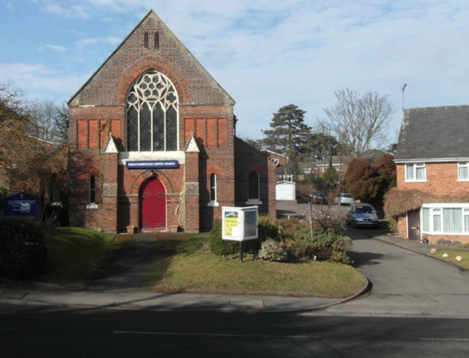
James William COLE, the grandfather of Leslie COLE and Victor COLE, was buried at the United Reformed Church in Wheathampstead (photo below). The following reference:
Wheathampstead families about James William COLE includes his tombstone inscription:
At the United Reformed ChurchFor many years, I did not understand why I could find the inscription on their tombstones but never a photo of their tombstones. In fact I could never find a graveyard associated with the United Reformed Church (which still exists). Eventually, I was studying a photo of the United Reformed Church and I noticed that there were many tombstones in the front yard of the church. The graveyard of the church must have been sold, probably to allow for the building of a new school located nearby. Some kind souls must have listed the inscriptions on these tombstones and published it on the web. Hopefully some day, before they are lost or crumble, someone will inspect the tombstones to see if my conjecture is correct. Recently, a kind soul, photographed some tombstones that had not be moved. Among them was the tombstone of James William COLE ((-1923). See his memories at FamilySearch for a photo of his tombstone.
ILMO James William Cole/ who died July 5th 1923/ aged 72 years/ "Resting"/ also/ Edith Sarah/ eldest daughter of the above/ who died April 6th 1930/ aged 50 years/ "Thy will be done"/ also Sarah Ann loving wife/ and mother of the above/ who fell asleep July 5th 1939/ aged 84 years.
Brewhouse Hill
AL4 8DQ Wheathampstead
Hertfordshire
More information about St Helen's Church is available at this site: St Helen's Parish Church where more photos below can be found.
(To enlarge .....Click it)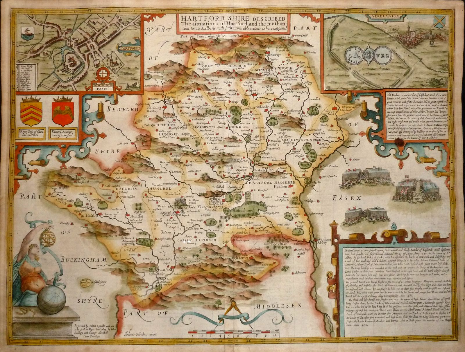 Map of Hertfordshire c1600 Wheatemstead is above the word "HUNDRED" of DACORUM HUNDRED Brockethall is midway between words "DACORUM HUNDRED" and "HARTFORD HUNDRED" (The faint lines are probably public footpaths of that time.) |
(To enlarge .....Click it)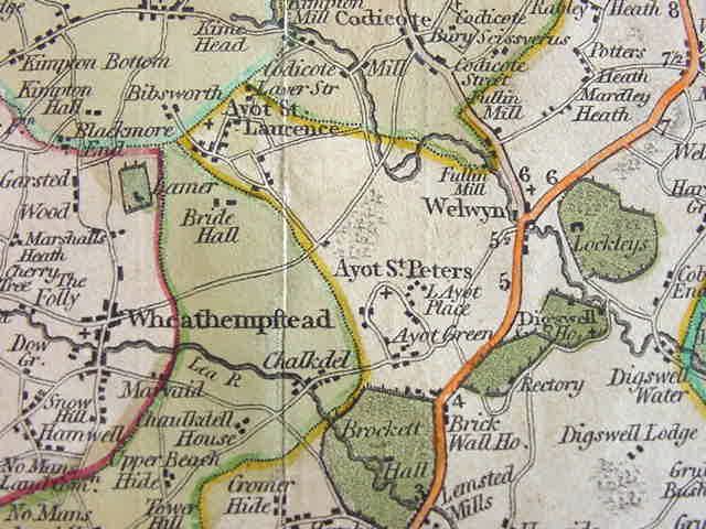 WaterEnd house is on this 1808 map of the Wheathampstead / Welwyn area ( facing the building touching the "d" of Chalkdel ) Note the use of the "long-S" in the word Wheathempstead. Printing of the "long-S" was rare after 1800. |
(To enlarge .....Click it)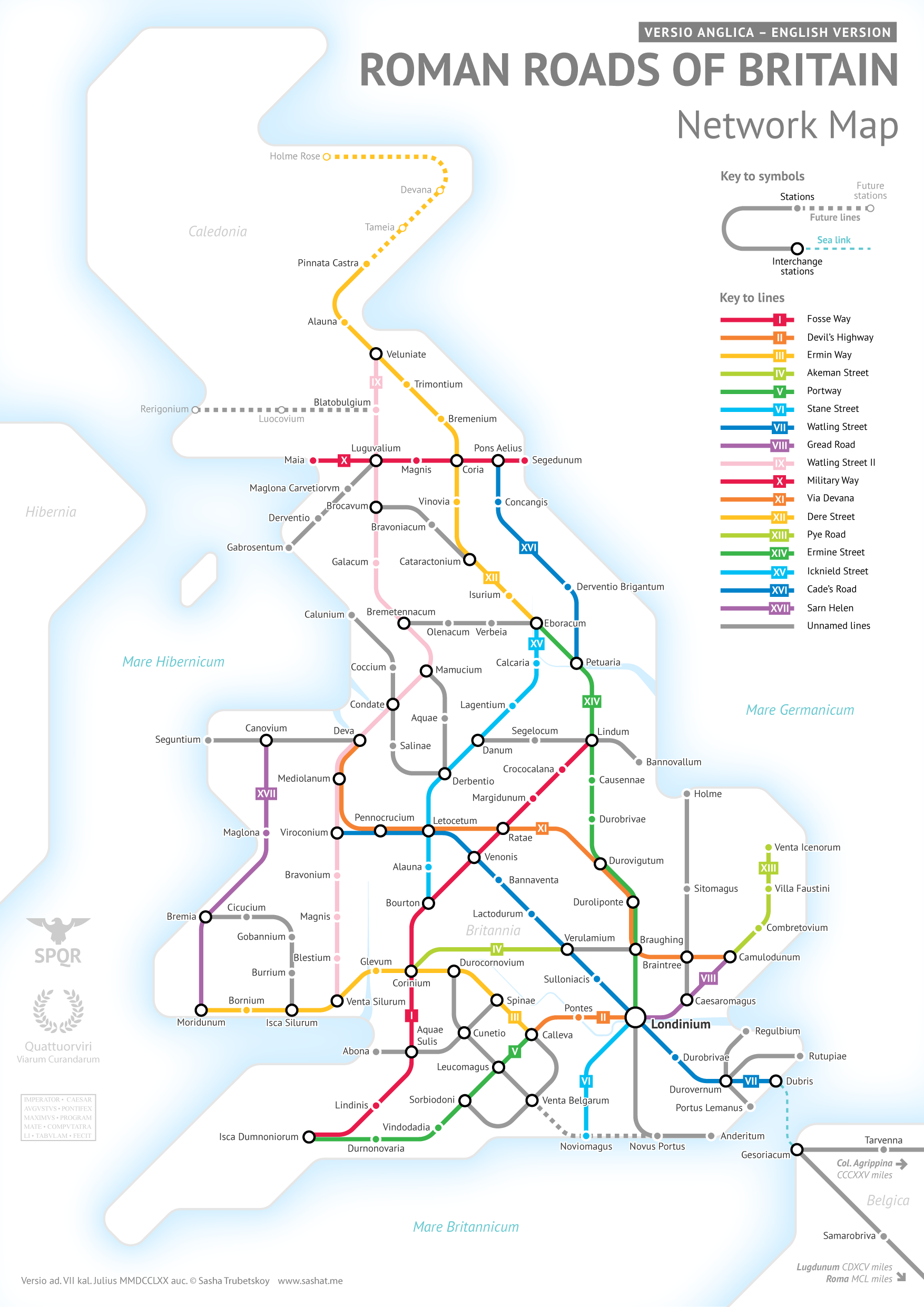
roman_roads_britain_150Metro |
(To enlarge .....Click it)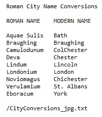
CityConversions_txt.jpg Camulodunum (aka Victricensis) |
(To enlarge .....Click it)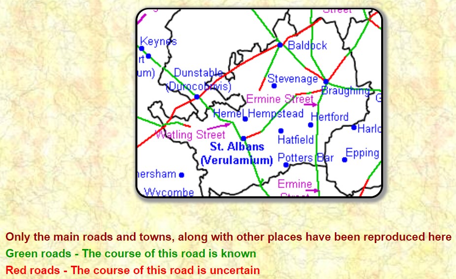
RomanRoad_Showing_Ermine_Street.jpg |
(To enlarge .....Click it)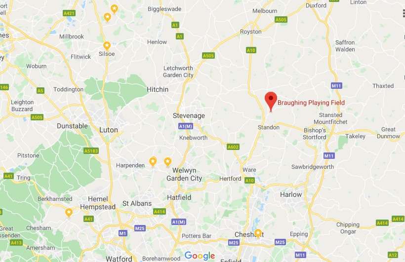
GoogleMaps_StAlbansAndBraughing.jpg |
(To enlarge .....Click it)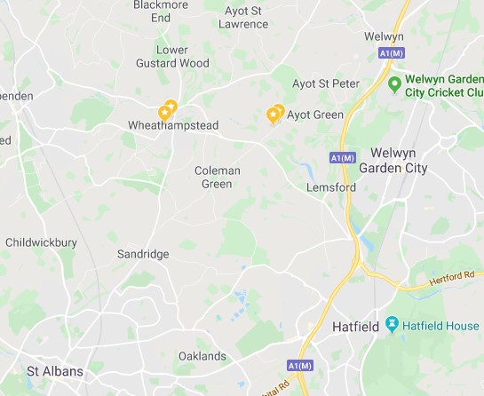
GoogleMaps_StAlbansToWelwyn.jpg |
 by Leigh Hatts by Geoffrey Gillon as of 2015 by wertypop as of 2015 FamilySearch IDs: LHJW-FJG and L1QB-D18 WikiPedia
The Genealogy of the Family of Cole...
by Leigh Hatts by Geoffrey Gillon as of 2015 by wertypop as of 2015 FamilySearch IDs: LHJW-FJG and L1QB-D18 WikiPedia
The Genealogy of the Family of Cole...  by James Edwin-Cole Date: 1867
Water End, Sandridge
at Hertfordshire-Genealogy.ca.uk by Chris Reynolds by Geoffrey Gillon by David Cole
The Roman Invasions-Documents
by Corinne Mills and Richard Hayton in 2014
The Devil's Dyke Walk in Wheathampstead
by AA Media Limited 2015
The Gardeners Chronicle Jul-Dec 1902
via mocavo.com 2015
Thomas de Grey . . inherited Wrest Park Estate
Wikipedia: Thomas de Grey - 2015
Wrest Park Estate
Wikipedia: Wrest Park - 2015
Genealogy in Hertfordshire
by Chris Reynolds - 2015
WaterEnd Barn by Harvey Wyman
by James Edwin-Cole Date: 1867
Water End, Sandridge
at Hertfordshire-Genealogy.ca.uk by Chris Reynolds by Geoffrey Gillon by David Cole
The Roman Invasions-Documents
by Corinne Mills and Richard Hayton in 2014
The Devil's Dyke Walk in Wheathampstead
by AA Media Limited 2015
The Gardeners Chronicle Jul-Dec 1902
via mocavo.com 2015
Thomas de Grey . . inherited Wrest Park Estate
Wikipedia: Thomas de Grey - 2015
Wrest Park Estate
Wikipedia: Wrest Park - 2015
Genealogy in Hertfordshire
by Chris Reynolds - 2015
WaterEnd Barn by Harvey Wyman